Decoding the Sprawl: A Strategic Guide to Navigating Los Angeles Like a Pro
Los Angeles inspires dreams, but its legendary scale can quickly turn into a logistical nightmare for the uninitiated. The key to unlocking the city’s magic lies not in avoiding its expanse, but in mastering a strategic approach to moving through it. Success here is defined by understanding that Los Angeles is not a single downtown core but a constellation of distinct, vibrant hubs. Consequently, the ultimate skill for any visitor or new resident is navigating Los Angeles efficiently. This guide moves beyond basic maps to provide the mental framework, tactical advice, and local secrets you need to traverse freeways, utilize growing transit, and discover walkable pockets with confidence. Transform the daunting sprawl into an accessible adventure.
Understanding the City’s Layout: The Basin and Beyond
First, discard any notion of a traditional city center from which everything radiates. Los Angeles County is a vast topographic mosaic. Think of it in major zones: the dense urban basin, the valley systems, and the coastal strip. The Los Angeles Basin itself, flat and expansive, holds Downtown LA, Hollywood, and the Westside. The San Fernando Valley (“The Valley”) lies north over the Santa Monica Mountains. The San Gabriel Valley stretches east.
Your mental map should prioritize corridors and clusters. Distances are significant; traveling from Santa Monica to Pasadena can easily take over an hour. Always plan your days geographically. Group activities in the same zone or along the same transportation corridor. The official Visit California Los Angeles guide is a good starting point for understanding regional attractions. Remember, the city’s layout demands a hub-and-spoke approach to exploration, not point-to-point zig-zagging across its breadth. This type of strategic planning is akin to the optimized routing we champion at SazTech Solutions, where efficiency in movement is paramount.
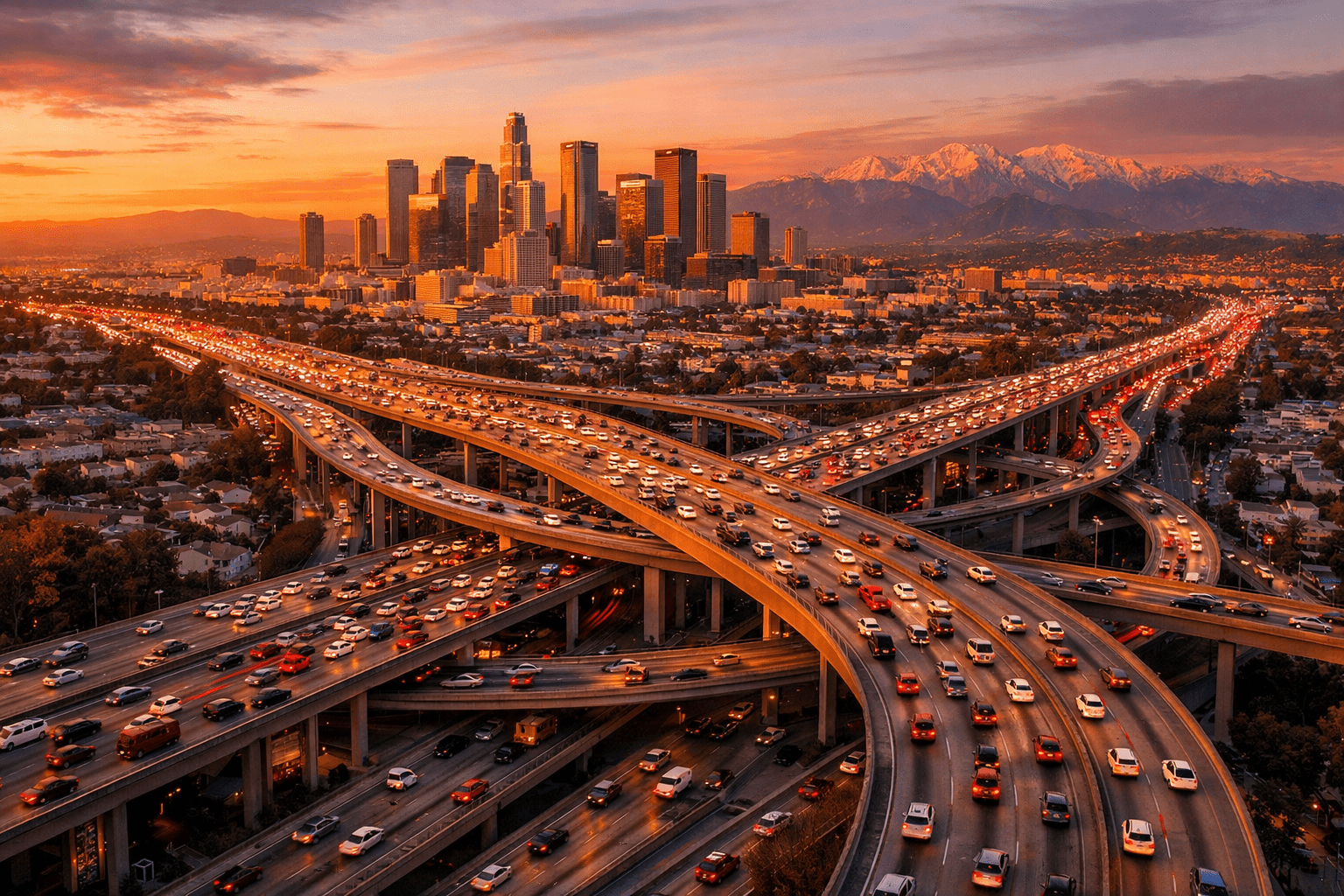
Major Arteries & Key Corridors: The Freeway Framework
Los Angeles runs on its freeway system. Knowing a few key routes is essential for navigating Los Angeles efficiently.
The East-West Lifelines
The 10 Freeway (Santa Monica Freeway) is the crucial east-west artery. It connects Santa Monica, Mid-City, Downtown LA, and stretches out to San Bernardino. The 101 Freeway (Hollywood Freeway) runs from Downtown through Hollywood and into the Valley, eventually heading north to Ventura. For a more scenic, albeit slower, east-west route, Sunset Boulevard traverses the entire city from Echo Lake to the Pacific Ocean.
The North-South Backbones
The 405 Freeway (San Diego Freeway) is arguably the most infamous. It is the spine of the Westside, running from the San Fernando Valley through LAX, Long Beach, and Orange County. The 110 Freeway (Harbur Freeway) connects Downtown LA to San Pedro and contains a historic Arroyo Seco Parkway section. The 5 Freeway (Golden State/Santa Ana Freeway) is the major interstate cutting diagonally from the north through Downtown and down to Orange County.
Pro Tip: Navigation apps are non-negotiable. Use Waze or Google Maps in real-time to check traffic conditions before every trip. The difference between the 10 and the 10 can be 30 minutes. Reliable navigation tools, much like the reliable, round-the-clock services businesses depend on, are essential infrastructure for success in LA.
Neighborhoods & Districts Guide: Know Your Destinations
Los Angeles is a city of neighborhoods, each with its own personality. Understanding their relative positions and vibes is crucial for planning.
- Downtown Los Angeles (DTLA): The evolving urban core. Home to museums (The Broad), concert halls (Walt Disney Concert Hall), historic markets (Grand Central Market), and sports venues (Crypto.com Arena). Increasingly walkable.
- Hollywood: More than the Walk of Fame. It includes the Hollywood Bowl, Griffith Park entrances, and historic studios. Traffic is perpetually heavy.
- The Westside: Encompasses Beverly Hills, Westwood, Century City, and Culver City. Upscale, with major shopping and studio lots. Culver City has a charming, walkable downtown.
- Santa Monica & Venice: Coastal hubs. Santa Monica has the iconic pier and a dense, walkable downtown near the Expo Line terminus. Venice offers the chaotic creativity of the Boardwalk and the serene canals.
- Mid-City & Wilshire: Includes the Miracle Mile museum row (LACMA, La Brea Tar Pits) and Koreatown, a dense, late-night dining paradise.
- San Fernando Valley: Studio City, Universal City (home to Universal Studios Hollywood), and Burbank offer a more suburban feel with major entertainment industry footprints.
- Pasadena & Northeast LA: Pasadena, with its Old Town and the Rose Bowl, feels like a separate city. Accessible via the Gold Line light rail. Northeast LA (Highland Park, Eagle Rock) is a hub of trendy dining and shops.
Public Transportation Navigation: Beyond the Car
While a car offers maximum flexibility, Los Angeles has a growing and useful public transit network. For certain trips, it’s the smartest choice. The Los Angeles County Metropolitan Transportation Authority (Metro) system includes buses, light rail, and subways.
Rail Lines for Key Routes
The Metro Rail system connects many major destinations. The B (Red) Line subway runs from Downtown through Koreatown, Hollywood, to Universal City and North Hollywood. The A (Blue) Line light rail connects Downtown to Long Beach. The E (Expo) Line is a game-changer, running from Downtown to Culver City and Santa Monica. The L (Gold) Line (now part of the A Line) heads to Pasadena and East LA.
Purchase a reusable TAP card. You can load it with cash value or day/week passes. Using transit for straight-shot trips, especially during peak traffic or to dense areas like DTLA where parking is expensive, is a hallmark of navigating Los Angeles efficiently. For detailed system maps and trip planning, always consult the official Metro maps page.
Driving & Parking Strategies: The Art of the Road
If you drive, you must master local customs. Lane discipline is fluid. Signal changes early. The “California roll” at stop signs is common but not legal. Most importantly, understand that the left lane on the freeway is for passing, not cruising, even in heavy traffic.
Parking: A Crucial Calculus
Parking dictates the success of your outing. Look for signs noting street cleaning days and times to avoid costly tickets. In commercial areas, expect metered parking. Apps like ParkMobile or PayByPhone are widely used. Lots and structures are plentiful but pricey in areas like Hollywood, Downtown, and Beverly Hills. Factor a $10-$20 parking budget into your daily plans. Some neighborhoods, like West Hollywood or parts of Santa Monica, have resident-only restrictions. When in doubt, find a paid lot—it’s often less stressful than hunting for 30 minutes. If you need assistance planning complex logistics in the city, feel free to contact our team for insights into efficient operational planning.
Walking & Biking Routes: Discovering LA’s Pedestrian Pockets
While not a walking city overall, LA has fantastic walkable enclaves. You just need to know where to find them.
- The Hollywood Hills: Hike Runyon Canyon or the trails at Griffith Park for iconic city views and a break from the car.
- Santa Monica to Venice Beach Path: The flat, paved oceanfront path is a glorious 3-mile stretch perfect for biking, skating, or walking.
- Downtown Los Angeles: The Historic Core, Broadway Theater District, and Bunker Hill are best explored on foot. Use the Metro to get downtown, then walk.
- Old Town Pasadena & The Rose Bowl Loop: Pasadena’s Colorado Boulevard is a classic walking street. The 3.1-mile loop around the Rose Bowl is a favorite for joggers and cyclists.
- Bike Share: Metro Bike Share has stations in DTLA, Venice, and Santa Monica. It’s a perfect way to cover short distances in these areas. Always wear a helmet and be hyper-aware of traffic.
Landmark Navigation & Viewpoints: Orienting Yourself in Style
Use LA’s landmarks as natural navigation aids and rewarding destinations.
Griffith Observatory offers the quintessential postcard view of the Hollywood Sign and the basin. Parking is challenging; consider taking the DASH Observatory shuttle from the Metro Red Line Vermont/Sunset station. The Getty Center in Brentwood provides stunning art, architecture, and westward views to the ocean. Parking requires a reservation but is inexpensive. The Top of the World hiking trail in Pacific Palisades delivers breathtaking ocean vistas. For an urban panorama, visit the OUE Skyspace or the rooftop bar at the Perch in DTLA.
Planning your route to include these viewpoints often means navigating Los Angeles efficiently by pairing them with other activities in the same geographic zone, like combining the Getty Center with a trip to Santa Monica.
Day-Trip & Itinerary Planning: Putting It All Together
Here’s how to apply these principles to actual itineraries.
Sample Day: Culture & Urban Energy (Car Optional)
Start at The Broad or MOCA in DTLA (take Metro Rail in). Walk to Grand Central Market for lunch. Afterwards, take the Metro B (Red) Line to Hollywood/Highland to see the Walk of Fame and TCL Chinese Theatre. Finally, use the same Red Line to go to Universal City for Universal Studios Hollywood or CityWalk. You’ve used one rail line to connect three major hubs.
Sample Day: Coastal & Creative (Car Helpful)
Drive to Santa Monica early for parking. Enjoy the pier and Palisades Park. Rent bikes and ride the beach path south to Venice Beach, exploring the Boardwalk and Canals. Drive inland to Abbot Kinney Boulevard for shopping and dining. This day clusters coastal activities without crossing the city.
For authoritative information on regional attractions and trip ideas, complement this guide with resources from the Los Angeles Tourism & Convention Board.
Seasonal & Local Considerations: Timing is Everything
Traffic and accessibility have seasonal rhythms. Summer brings tourists, meaning heavier beach traffic on the 10 and 405. “June Gloom” brings morning coastal clouds. Fall offers the clearest skies and warm weather. Winter is rainy season (yes, it rains in LA), which causes dramatic slowdowns on slick freeways. Spring is ideal, but be aware of “Carmageddon”-style closures for major events like the LA Marathon or Hollywood Christmas Parade.
Local Tip: Avoid key freeways during rush hour, typically 7-10 AM and 3-7 PM. If you must drive then, use your app’s “depart at” feature to see estimated times. Friday afternoons are notoriously bad citywide. Conversely, Sundays often have lighter traffic until evening.
Conclusion: Your LA Navigation Mindset
Navigating Los Angeles efficiently is less about memorizing every street and more about adopting a strategic, cluster-based mindset. Accept the distances. Plan your days by geographic zone. Use real-time traffic data religiously. Embrace public transit for direct routes. Seek out the walkable and bikeable pockets. Most importantly, view the journey as part of the LA experience—the radio, the views, the people-watching. With this guide’s framework, you can move from anxious outsider to confident explorer, mastering the sprawl and unlocking the unparalleled diversity of experiences that make Los Angeles a world-class destination. The city is yours to discover, one well-planned route at a time.


Leave a Reply